Mt Katahdin Hike, September 2005
Moose cow and calf on Sias Hill Road, after Greenville, not quite to First Roach Pond and the cabin where I'd be spending the weekend and using as base to travel to Baxter State Park and Mt. Katahdin.

View of Katahdin, 50 miles northeast, from the porch (with 105mm lens) of my grandparents' cabin on First Roach Pond.
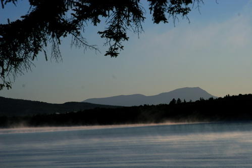
Closer view of Katahdin from Baxter Park Rd, a disintegrated "paved" road to Baxter State Park.

Once inside Baxter State Park you have to stop at a gate and pay $12 for day use of the parking lots and campgrounds. They take your name and license plate number and ask you for an emergency contact number. From there I drove to the base of the Abol Trail, the oldest trail up Katahdin and one of the most dangerous, at Abol Campground. Last time I didn't have enough cash on me and I walked over 5 miles from the park gate to the trail base. That time I only made it about half way up the mountain and walked most of the way back in the dark. This time I was prepared with cash, flashlight, water, camera, etc. After hiking up through deep dark woods, rocks, tree roots and mountain streams for a couple miles you make it to the Abol Slide -- a wash of granite boulders, rubble and gritty sand formed by avalanches. That's when the hike gets hard. Eventually it gets steeper and steeper and you realize why there are no small rocks -- everything but the largest boulders has already been shook loose and slid down the side of the mountain. You are pulling yourself up and over car-sized, algae-covered boulders as you climb higher and wonder when it will end. Looking up you have some idea of where it ends, and you can't see past that point, which isn't the peak, but more like a the edge of a table . . .

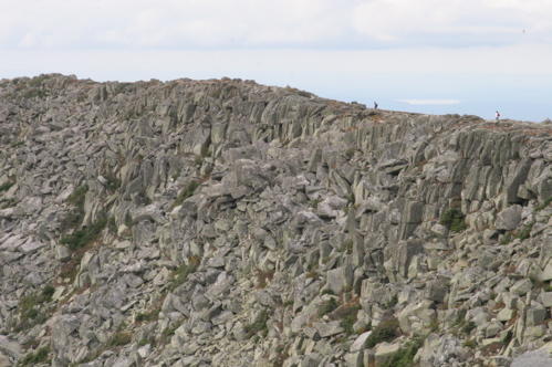
The view gets better and better as you climb. It's dizzying to look up, down or out at the panoramic view, which is just impossible to capture with any normal camera lens. This is just a shot looking back down toward the southwest from near the edge of the top.

At last you clamber over the last boulders to flat land. You can stand and see some kind of two-tone rust and green sedge or grass covering the ground in front of you. To the left the Hunt Trail comes in across another ridge of boulders, the last leg of the Appalachian Trail.
To the right is the last mile to Baxter Peak, gradually rising 800 feet or so to the tallest point on Katahdin. But first a stop at Thoreau Spring, streaming out of the ground, to refill my water bottle with cool, clear water.

The view of Brother Mountains, the Owl and other mountains from Katahdin is amazing.

With the general purpose lens I brought, I am afraid I wasn't able to capture the beauty that well, but I like this picture with the western mountain peaks peeking over the ridge of the rust-colored table land.

After a mile along a rocky trail marked by regular cairns, gradually hiking up over rocky tundra-like terrain you reach the peak, which is marked by a large, weathered sign (obligatory photo follows) and a seven foot cairn (not shown).

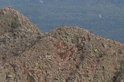
Coming from the southern side of the mountain it is only when you finally get to the peak that you can see the famous Knife Edge -- a steep, narrow ridge that follows the peaked ridge of Katahdin from Baxter Peak to the slightly shorter South Peak and finally to Pamola Peak. The Knife Edge is beautiful, dramatic and scary.

Up close you can make out some hikers making their way across the Knife Edge. It's amazing how putting an object such as a person in a picture like this clarifies the scale of the scene.

Actually, at the size allowed by the blog, you can't see them. Here's a cropped photo from the middle of the photo above. You can make out hikers at this scale.
The north side of the mountain is a large basin with a pond near the center. There are roads and trails through the park to camp down there and hike up to the peak from different angles.

Here I am on top of Katahdin, composed rather than smiling because I've got braces on both my upper and lower teeth now and am self-conscious about it.

After hanging around on the peak for a few, taking pictures, catching the view, watching a hawk, and tripping and denting my camera lens barrel I decided I was fairly tired, it was getting close to evening, and I knew I had about three hours of hiking ahead of me to get back to my car.
The hike back down the rock slide seemed more dangerous than coming up it. Once I was back in the woods I was comfortable and moved along quickly. By the time I got back to Abol Campground bats were flitting right in front of my face and campers had their camp fires going strong. I drove out of the park very happy. I had a long drive, about one and a half hours, half over paved road, half over dirt roads, to get back to the cabin and rest. Soon after my return to the cabin my father called. We had a good chat. Then I relaxed on the porch and listened to loons calling longingly in the night.
posted by Scott M. Stirling @ 12:09 AM
0 comments
![]()
![]()


0 Comments:
Post a Comment
<< Home